With the exception of male models in carefully creased fishing vests hawking angling gear in magazines, I’ve been reluctant to piss on fellow members of the angling brotherhood. Ditto for television and radio personalities, as I’ve assumed them to be reasonably honest versus an avaricious SOB, whose focus is to promote their guide service. Most sins of exaggeration or inaccuracy chalked up to the notion that angling media are akin to weather people; they mean well, but rarely get the forecast correct.
That’s a nicety I’ll no longer observe.
After six or seven weeks scrimmaging with Lake Berryessa in hopes the “top water bite” would materialize, I’m convinced we won’t have one this year – compliments of the California drought.
This being in sharp contrast to the pundits on the Bob Simm’s radio hour, which insists that anything with fins is climbing the bank begging to be hooked – on dry land even.
Personal observation and discussions with fellow fishermen suggests no one can figure out where the fish are – and that extends to the Kokanee Salmon and anything else plying the waters of that drainage.
Us fly fishermen, ever mindful of Science, have always insisted on the plausible explanation and Latin-tinged theorem, rather than relying on the more mystical, “… use the Big Red Sumbitch – Let God Sort Them Out” approach popular with bass fishermen everywhere.
While much is known about river dynamics and flowing water, lakes have always proven a bit of enigma for fly fisherman. We look for the same things we see on rivers; bugs, differing currents, weather, and cover, but we’re ill at ease given that lake fishing exposes the soft underbelly of fly fishing – how poorly our tackle sinks and how deep water is our absolute undoing.

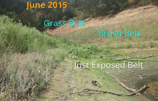
I took the above picture of Berryessa’s banks in June of last year, just before the blast furnace of summer hit the area.
The Grass Belt is the historic fill level of the lake. If the lake is full, that water will rise to that region, about 10-30 feet from the tree line. The Brush Belt is the area exposed during the 2014 drought year. It has had seeds drift into that area from both wind and receding waters, and the growth has been buttressed by what little moisture fell during the 2014 Winter and Spring of 2015. The Just Exposed Belt is the area that has receded during the meager 2015 Spring, and will dry further as the 2015 Summer bakes the area.
By the end of Summer 2015, the loss of water had exposed nearly 200 feet of bank on the steeper canyon areas – which translated into half a mile or more of shallows exposed in the wider portions of the lake.
This Spring we had one superb storm that lifted the lake level at least 30 feet from its 2015 low point. On the shallow ends of the lake those flats exposed were reclaimed by the waters, leaving shore anglers the ability to cast only to the recently reclaimed area, now thinly covered with water.
Clue 1: Those ain’t weeds, those are Stems
In the bays formed by the undulating shoreline, the sudden glut of water had covered the exposed soil in wooden debris and terrestrial plant stems. No leaves or greenery suggesting they were of recent vintage, rather they were sodden and waterlogged, with enough woody material to lift them to the surface, where the wavelets formed by the boat traffic piled them in heaps at water’s edge.
Looking at the above picture, and remembering the sequence of events – suggested this was the remnants of the Brush Belt. Once lush and green during Spring, now dried and dead from Summer, and forced underwater by the rising lake.
The idle currents near the shore break the stems into pieces, and they have enough pithy material to float ashore. These stems represent the only cover remaining underwater, leaving a featureless dirt embankment with no cover for hiding or ambush.
Clue 2: Where’s the forage?
Any self respecting minnow knows immersion in water teeming with hungry and voracious predators, requires both cover and shade, things that you can hide among or behind, anything that allows the minnow school to pursue insects and forage suitable for their survival
These schools of bait were visible all of last year. Weed beds and plant growth would die once the water receded and exposed them to the harsh daytime temps, but the schools of forage fish would recede with the water – as the weeds blanketed the lake floor.
Add thirty feet of water delivered over a single week of runoff, and you have many hundreds of feet of dead soil now covered with water, but lack weeds, shade, or cover of any kind.
No cover means no bait, and that means no fish other than the occasional cruising bass.
Clue 3: Where are the beds?
Bass spawn in shallow water, leaving scarred whitish areas that the female sweeps clean with her tail. Often she stays on the bed, which is part of the allure of the Spring top water bite … big fish, shallow water, and the desire to kill anything approaching the nest.
Bass anglers have always taken advantage of this phenomenon with great glee, as there’s nothing more exciting then the visual element associated with casting at visible fish. The notion of “cradle robbing” apparently is suspended for the duration of the festivities …
This year I have seen only a single bed – covered by a solitary fish. It was in a back bay whose bottom had lots of algae and cover, suggesting bass also look for cover and shade to offer protection from predators.
The clean dirt areas are devoid of life. No beds visible, almost no foliage or weed growth, and few fish prowling for food.

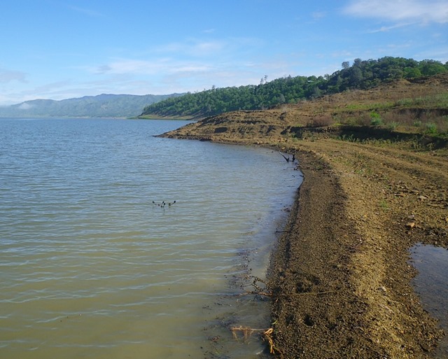
The above photo shows a “dead zone” bank. All dirt, no foliage of any kind as it was dried and desiccated by 2015’s summer sun. Note the pithy debris at water’s edge – mostly dried stems and dried thistle clumps (also shown in the water).
This lack of foliage means the dust in the soil leeches into the water as soon as boat wakes bathe the area. This thick band of dirty water provides the only cover for many hundreds of feet, and I always keep a weather eye out for signs of baitfish. So far, nothing.
Conclusion: Boat fishermen are better off
With no cover available to harbor baitfish, and with the water depth denying us that area of the lake that still has cover, my dismal conclusion is that the fish, their beds, and the minnow forage, are all too far from shore for bank fishermen to take part.
Six trips, in as many weeks, has yielded no fish activity of any kind.
I’ve not seen a boat angler catch a fish either – as many are fishing in close to the bank – consistent with a traditional wet year. I’m thinking that deeper water still retaining weeds and cover are where the fish are and the typical mobile bass angler is motoring past them enroute to joining me in the Dead Zone.
Like Misery I surely loves the company, but I wish they would heed my “wave off.”

Not only Berryessa, but all the lakes are having the same problem with the exception of New Melones. New Melones doesn’t have any water in it, therefore no shore problems. I quit listening to Bob Simms years ago for the exact reason you stated above. We’ll need many years of good rain to return the lakes to what they were back in the day.
The Good News being Shad season starts this month – now we can find out how the drought has dealt us another pair of deuces?
I’m an optimist, I’ll meet you midstream for whatever Nature has in store …